FLOOD CONTROL
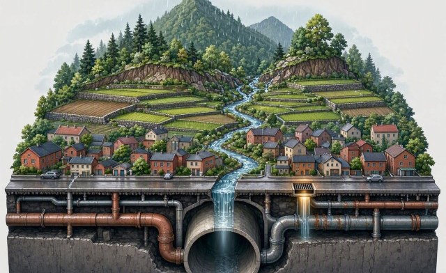
From the Little Grate to the Big Spillway
By Karl M. Garcia
THE FLOOD DOES NOT BEGIN IN THE STREET
Every time Metro Manila floods, we look for a culprit.
A clogged drain.
An overflowing creek.
A failed pumping station.
A blocked estero.
An undersized pipe.
A river that has breached its banks.
A catch basin buried beneath garbage, leaves and sediment.
All of these can be true.
But they are usually only where the failure becomes visible.
The flood may have begun much earlier.
It may have begun with a forest cleared upstream. A slope destabilized. A quarry that altered drainage. A subdivision that replaced soil with concrete. A river narrowed by encroachment. Waste allowed to leak into waterways. Cooking oil poured into a drain.
Grease cools inside pipes. Hair, food particles, fibers, soil and other debris adhere to it. Layer by layer, the opening becomes smaller.
A little waste becomes a hydraulic obstruction.
Then the storm arrives.
Water cannot enter the drainage system quickly enough. Or it enters but cannot move downstream. The network backs up. Streets flood. Creeks rise. Rivers approach capacity. Laguna de Bay rises.
We see a clogged pipe, a flooded street, a swollen river and a rising lake as separate problems.
They are not.
They are different points in the same water system.
That is the fundamental mistake in how we think about flood control.
We manage projects when we should be managing systems.
THE LITTLE GRATE
A catch basin has a simple purpose:
Get water from the street into the drainage network.
Yet that little grate is the first node of a much larger system.
If leaves cover it, water stays on the street.
If plastic blocks it, capacity falls.
If sediment accumulates, the opening becomes less effective.
If grease and debris obstruct the pipe below, cleaning the grate accomplishes very little.
If the receiving creek is already full, the drainage system backs up.
If the river is at flood stage, the creek has nowhere to discharge.
If the tide is high, gravity drainage can become ineffective.
This is why maintenance is not an administrative afterthought.
Maintenance is flood-control infrastructure.
A country that cannot keep its small drainage systems functioning will struggle to make its largest flood-control projects perform.
THE WASTE PROBLEM HIDING INSIDE THE WATER PROBLEM
Some flood-control failures are visible.
Others are hidden.
Grease is one of them.
Used cooking oil and grease should not be poured into drains. Once they adhere to pipe walls, they can become the surface around which other material accumulates.
This is where categories that government traditionally separates begin to collide.
Solid waste becomes a drainage problem.
Wastewater becomes a flood problem.
Land use becomes a river problem.
Erosion becomes a lake problem.
The watershed connects them.
That is why flood control cannot be separated completely from sanitation, waste management, pollution control and land-use planning.
The question is not merely:
Where does the water go?
It is also:
What is the water carrying with it?
WE CANNOT SIMPLY DRAIN OUR WAY OUT
For decades, the instinct has been straightforward:
Get the water out.
Build bigger drains.
Dredge the river.
Straighten the channel.
Install pumps.
Move the water downstream.
All of these have their place.
But there is a fundamental problem.
There is always a downstream.
If every locality tries to discharge stormwater as quickly as possible, the downstream system eventually receives the combined peak.
What solves a problem in one place can intensify pressure somewhere else.
Modern flood management therefore needs a larger vocabulary:
Capture. Slow. Store. Infiltrate. Reuse. Convey. Pump. Release.
That means detention and retention areas, floodable parks, wetlands, rain gardens, bioswales, permeable surfaces and underground storage where appropriate.
It means protecting floodplains and natural waterways.
It means requiring new developments to manage some of their own stormwater instead of transferring the entire burden downstream.
Drainage remains essential.
But drainage alone is not flood management.
FROM THE MOUNTAIN TO THE BAY
Now zoom out.
Rain falls across a watershed.
What happens next depends on everything that lies beneath it.
A forest influences runoff.
A cleared slope behaves differently.
A mine or quarry can alter drainage and sediment loads.
A poorly designed road can redirect water.
An unstable slope can produce a landslide.
A farm can contribute sediment and nutrients.
A subdivision can dramatically increase impervious surfaces.
A city generates wastewater and solid waste.
A dumpsite can generate leachate.
A waste-treatment facility can generate residual materials that still require proper management.
Everything eventually converges in the waterways.
The river is not merely carrying rain.
It is carrying the accumulated consequences of decisions made throughout the watershed.
That is why the real unit of flood management is not the drainage pipe.
It is the watershed.
LAGUNA DE BAY IS NOT A BATHTUB
This becomes especially important when we reach Laguna de Bay.
The lake is not simply a container into which we can pour excess water.
It is a fishery.
A food-security resource.
An ecological system.
An economic asset.
A freshwater resource.
And, in the language of infrastructure, it is natural infrastructure.
The Manggahan Floodway was designed to divert floodwater toward the lake. But once water is deliberately sent into Laguna de Bay, another question becomes unavoidable:
Where does that water go?
This is the logic behind the long-discussed Parañaque Spillway.
The project has now been revived by the Marcos administration as a major component of long-term flood management. Current plans call for a roughly 10.5-kilometer underground tunnel, with a project cost estimated at around ₱90 billion. The proposed system would provide a controlled outlet from Laguna de Bay toward Manila Bay.
The scale is enormous.
But the principle is the same as the little grate.
Water has to move somewhere.
THE PARANAQUE SPILLWAY: THINK SYSTEM, NOT MEGAPROJECT
The Philippines should seriously examine the Parañaque Spillway.
But we should also ask the right question.
Not:
Will the spillway solve flooding?
The better question is:
What national water-management system will the spillway become part of?
A spillway is hydraulic capacity.
It does not replace watershed rehabilitation.
It does not replace drainage maintenance.
It does not replace sewage treatment.
It does not stop erosion.
It does not eliminate solid waste.
It does not restore a polluted lake.
And it does not automatically eliminate flood risk.
Its job should therefore not simply be:
Get water out.
Its job should be:
Manage the movement of water.
That means controlled operation based on lake levels, rainfall forecasts, river conditions, downstream capacity, tides and other relevant hydraulic and environmental information.
The spillway should be infrastructure with intelligence, operating rules and accountability.
Not simply concrete and tunnels.
THE MUNTINLUPA TEST
There is another reason to think about the spillway as a system.
Large infrastructure inevitably affects people who live where the infrastructure must pass.
Muntinlupa has raised concerns about potential displacement and localized flood impacts. The underground design is intended to reduce surface disruption compared with older open-channel concepts, but local concerns cannot simply be treated as obstacles to be overcome.
They are information.
They tell us what the system looks like from the ground.
Before construction, government should be able to answer:
Who is affected?
Where will land be required?
What communities are displaced?
How will flood levels change in each locality?
Where will water enter and exit?
What happens during an extreme rainfall event?
What happens when Manila Bay conditions are unfavorable?
What happens if a critical component fails?
Who operates the system?
Who maintains it?
Who pays for maintenance?
Who is accountable when performance falls short?
A ₱90-billion project deserves more than a construction schedule.
It deserves a system architecture.
A SPILLWAY CANNOT SAVE A DYING LAKE
The same logic applies to Laguna de Bay itself.
The lake cannot become the country’s permanent dumping ground for everything upstream.
Untreated wastewater matters.
Industrial discharges matter.
Agricultural runoff matters.
Solid waste matters.
Sedimentation matters.
Aquaculture pressures matter.
Leachate matters.
Upstream erosion matters.
Therefore the choice cannot be:
Spillway or lake rehabilitation.
It has to be:
Spillway + watershed rehabilitation + pollution control + waste management + ecological restoration.
Otherwise we risk building expensive hydraulic infrastructure around a deteriorating ecosystem.
The lake must be treated as an asset worth protecting.
FROM RIVER CLEANUP TO RIVER MANAGEMENT
The Philippines has repeatedly followed a familiar cycle:
Pollution → accumulation → flooding → cleanup → temporary improvement → renewed pollution.
Cleanup is necessary.
But cleanup without learning becomes repetition.
The smarter cycle is:
Monitor → detect → analyze → intervene → measure → learn → prevent.
Trash traps, river barriers, dredging, pumping stations, river personnel, private-sector rehabilitation, Adopt-an-Estero programs and international technologies can all contribute.
But the important question is not simply:
How much waste did we remove?
It is:
Where did it come from?
Why did it accumulate there?
How quickly did it return?
Did incoming waste decline?
Did water quality improve?
Did flooding improve?
That is the difference between a cleanup program and river management.
INTERCEPTION IS NOT PREVENTION
Trash traps are useful.
Floating barriers are useful.
They intercept waste before it travels farther downstream.
But interception is the last line of defense, not the first.
The hierarchy should be:
Reduce → collect → segregate → recover → properly dispose → prevent leakage → intercept remaining leakage → clean accumulated pollution.
The same principle applies to grease.
Used cooking oil should be collected through legitimate recovery systems instead of entering the sewer.
Because once grease enters a pipe, an apparently insignificant household action can become part of a much larger hydraulic failure.
This is the systems lesson:
Waste management is flood control.
AND THEN COMES CIRCULARITY
Cleanup should not automatically mean disposal.
Recovered materials should be characterized and directed toward appropriate pathways.
Recyclables can return to material-recovery systems.
Organic materials may have recovery options where contamination permits.
Vegetation and branches may have productive uses where safe.
Used cooking oil can enter legitimate recovery systems.
Sediment should be tested before reuse.
Ash from thermal treatment must be properly characterized before beneficial use or disposal.
Circularity is therefore more than recycling.
It means:
Keeping materials in productive loops while keeping pollution out of the water system.
That is both an environmental principle and a flood-control principle.
GIVE THE WATER SYSTEM A MEMORY
Here is where the Philippines can do something deceptively simple.
Give the water system a memory.
Every catch basin should be mapped.
Give it a digital identification number.
Record its location.
Identify its drainage catchment.
Record the pipe it connects to.
Record when it was cleaned.
Record what was found.
Leaves?
Plastic?
Sediment?
Grease?
Record whether the location repeatedly floods.
Do the same for drainage lines, pumps, rivers, trash traps and major flood-control structures.
Then something powerful happens.
The country begins accumulating institutional memory.
Every intervention should answer:
What happened?
Where?
When?
What was done?
How much did it cost?
What worked?
What failed?
What happened afterward?
The next administration should not have to rediscover the same problem.
BUILD A DIGITAL WATERSHED
The Philippines should develop a national Digital River and Watershed Platform.
Not another decorative government dashboard.
A decision system.
It should connect rainfall, river and lake levels, drainage networks, pumping stations, catch basins, flood maps, water quality, land-use change, erosion, waste-interception points, maintenance records and satellite imagery.
Eventually it should be able to answer questions such as:
Where will debris accumulate after a typhoon?
Which drainage network is approaching capacity?
Which tributary contributes the most sediment?
Where should the next trash trap go?
Which pumping station is becoming a bottleneck?
Which river repeatedly overflows?
Which pollution source keeps returning?
This is where technology becomes useful.
AI SHOULD HELP US SEE THE SYSTEM
Artificial intelligence can help us find patterns that humans cannot easily see across thousands of locations and years of data.
Computer vision can identify floating debris.
Predictive models can forecast flooding.
Anomaly detection can flag unusual water-quality changes.
Satellite imagery can track land-use change, erosion and watershed degradation.
Machine-learning models can connect rainfall, river levels and historical flood behavior.
But we should not fall into another technological trap.
AI cannot fix an institution that does not work.
A sensor cannot replace sewage treatment.
A robot cannot replace waste collection.
A digital twin cannot compensate for inadequate drainage.
Technology is an amplifier.
If institutions are weak, technology can amplify weakness.
If institutions are capable, technology can amplify capability.
The objective is therefore not gadget deployment.
It is:
better decisions, faster responses and better outcomes.
MEASURE THE RIVER, NOT THE PROJECT
This should change how government evaluates flood-control spending.
Do not ask only:
How many kilometers of drainage were built?
How many cubic meters were dredged?
How many trash traps were installed?
How much money was spent?
Ask instead:
Are floods becoming shallower?
Are they becoming shorter?
Are they happening less frequently?
Is incoming waste declining?
Is water quality improving?
Are rivers carrying less sediment?
Are pumping stations functioning reliably?
Are watersheds recovering?
Are fisheries and habitats improving?
Is maintenance becoming more predictable?
Are agencies responding faster?
A project can be completed and still fail.
A system succeeds only when outcomes improve.
FIVE LAYERS OF A NATIONAL WATER SYSTEM
A Philippine water strategy can be organized around five connected layers.
1. PREVENTION
Waste management, sanitation, pollution control, EPR, industrial regulation, mining and quarry controls, forest protection and land-use planning.
2. INTERCEPTION
Trash traps, barriers, collection systems and strategic interception points.
3. PHYSICAL CAPACITY
Drainage, declogging, dredging, pumps, detention, retention, floodways, river restoration and major hydraulic infrastructure—including, where justified, the Parañaque Spillway.
4. INTELLIGENCE
Sensors, cameras, satellites, GIS, forecasting, AI and digital twins.
5. GOVERNANCE
National agencies, LGUs, barangays, communities, universities, private companies and international partners operating from shared information, common standards and clear accountability.
The five layers reinforce one another.
Prevention reduces the load.
Interception catches leakage.
Physical infrastructure moves and controls water.
Intelligence tells us what is happening.
Governance makes the system work.
That is flood control.
Not a collection of projects.
A system.
TURN PARTNERSHIPS INTO CAPABILITY
International partners can provide technology, engineering and knowledge.
Private companies can provide equipment, financing and operational expertise.
Universities can provide research and independent validation.
Communities can provide local intelligence.
Government provides regulation, coordination, public accountability and long-term direction.
But partnerships should not simply create another five-year project.
They should leave behind Philippine capability.
The sequence should be:
Find → test → deploy → measure → train → localize → improve → innovate.
The real measure of technology transfer is not whether a foreign company successfully deployed its technology.
It is whether Filipinos eventually know how to operate, maintain, improve and eventually innovate upon it.
THE REAL RETURN ON THE SPILLWAY
This brings us back to the Parañaque Spillway.
Its value should not be measured only by the concrete, tunnel length or construction cost.
The real question is what we build around it.
A spillway connected to catchment mapping is more valuable than a spillway alone.
A spillway connected to modern drainage is more valuable.
A spillway connected to watershed protection is more valuable.
A spillway connected to pollution control and waste management is more valuable.
A spillway connected to lake rehabilitation is more valuable.
A spillway connected to sensors, forecasting and real-time operating rules is more valuable.
A spillway connected to capable institutions is vastly more valuable.
The same principle applies to a ₱10-million drainage project.
The structure is only one part of the investment.
The greater investment is the capability to operate, maintain, measure and improve it.
FROM THE LITTLE GRATE TO THE BIG SPILLWAY
The little grate teaches us something important.
Small infrastructure matters.
The blocked pipe teaches another lesson.
Waste can become a hydraulic problem.
The river teaches us:
Maintenance must become learning.
The watershed teaches us:
Land use is water management.
The lake teaches us:
Natural infrastructure has limits.
And the spillway teaches us:
Large infrastructure matters—but only as part of a larger system.
A clean grate cannot overcome an overflowing river.
A larger pipe cannot solve an overloaded watershed.
A pumping station cannot create downstream capacity.
A trash trap cannot replace waste collection.
Dredging cannot permanently compensate for erosion upstream.
A spillway cannot restore a polluted lake.
And cleanup cannot substitute for prevention.
The chain is continuous:
mountain → forest → mine and quarry → slope → farm → city → household → drain → creek → river → lake → bay.
Alongside it runs another chain:
consumption → waste → leakage → obstruction → pollution → cleanup → recovery → reuse.
Our task is to close the second loop before it damages the first.
For too long, Philippine flood control has been organized around projects.
A drain here.
A pumping station there.
A dredging program somewhere else.
A trash trap downstream.
A river cleanup after the flood.
Then another administration starts the cycle again.
We need to stop thinking of flood control as a series of projects.
We need to build a national water-and-watershed operating system.
One that can see the smallest catch basin and the largest lake as parts of the same network.
One that understands that a grease-clogged pipe, a landslide, a polluted river, a degraded watershed and a rising lake are not unrelated events.
They are signals from the same system.
The objective is therefore not simply:
Stop the next flood.
It is:
Build a Philippines that knows where water comes from, where it goes, what it carries, where it can safely stay, what obstructs it, and when it must move.
That means moving from:
build → flood → clean → repair → repeat
to:
prevent → capture → monitor → manage → recover → learn → adapt.
From the little grate to the big spillway.
From waste management to watershed management.
From river cleanup to river intelligence.
From fragmented projects to connected national capability.
Because the flood does not begin when the street becomes a river.
It begins much earlier—
on the mountain,
in the watershed,
in the waste stream,
at the kitchen sink,
around the catch basin,
inside the pipe,
and ultimately in the decisions we make about land, water, waste and infrastructure.
That is where resilience must begin.


Many thanks Karl.
ABS-CBN News Channel on X: “Once regularly submerged by severe flooding, Imus City was spared from major inundation during last week’s onslaught of the southwest monsoon, thanks to a massive retarding basin built by the Japan International Cooperation Agency (JICA) in Barangay Anabu 1-G, Mayor Alex https://t.co/l94CZamhOg” / X – this would be a real life example of what is discussed in this article
Many thanks too.
When it comes to flood control, passive engineering (as opposed to hard engineering) such as retarding basins, urban wetlands, and sponge parks, is the correct way to go in most cases, but AFAIK in the Philippines passive methods are in actual the hardest to achieve.
Main reasons why passively engineered flood control projects are hard:
For convenience, the ABS-CBN article posted within Irineo’s X/Twitter link:
ABS-CBN: Retarding basin reduces flooding in Imus, set as model for planned Central Luzon detention basins
It looks like when DILG Sec. Jonvic Remulla was Governor of Cavite, he took it upon himself to be the coordinator between the national government, JICA, and the local executives of the affected LGUs in order to defuse the scenarios I outlined above. The Japanese are famously risk-aware, with JICA being especially risk-adverse. I’ve read countless stories in Philippine media of a supposed JICA-funded and engineered project having funding pulled out because the local authorities couldn’t get their ducks lined up in a row. So clearly Remulla did well here on the Imus Retarding Basin. In the article Remulla mentions the Imus Retarding Basin is a “good example” that that he hopes will “expand this good model nationwide” with continued JICA assistance. I believe the real lesson learned that should be replicated is how Remulla got all the “ducks lined up in a row” with regard to this particular project in order to ensure smooth execution.
One of the problems with projects in the Philippines is they are completed then ignored. Maintenance occurs when something breaks. So pumping stations fall useless, drains clog, and people build structures on river banks. When an LGU gets its act together, as Irineo points out, this can be avoided. But LGUs are mainly incompetent political organizations with management done casually, not purposefully. The country builds great four lane national highways but few large vehicles use the right lane because they are dangerous. Telephone polls, parked vehicles, unmarked narrow bridges, and dogs. Rivers are not attended to. It’s 2026 and Filipinos still dump plastic out the bus window.
National needs to develop incentives for LGU good governance. And it needs to hold Agencies accountable for incompetence. One month in jail for the agency head for every telephone pole found in the right lane. I mean, c’mon. Inject some attention to detail.
The Robredos and Vico Sotto’s tribe( not blood related) must increase to beat the system of incompetence.
Beyond Flood Control: Building a Water-Resilient PhilippinesFrom Cainta and the Pasig-Marikina Basin to NLEX and Central Luzon
The Philippines has traditionally approached flooding one project at a time: clear a creek, deepen a canal, build a pumping station, widen a drainage pipe, repair a bridge, or raise a road.
That approach is increasingly inadequate.
Flooding does not respect political boundaries or project classifications. Rain that falls in the mountains eventually reaches the valley. Water blocked by a bridge affects communities downstream. A clogged river affects roads, subdivisions, farms and industrial areas. A dam, drainage system, highway and floodplain are therefore not separate problems. They are components of one hydrological system.
The emerging flood-control projects in Cainta and the Pasig-Marikina River Basin, together with the proposed elevation of NLEX in San Simon, Pampanga and calls to restore blocked waterways in Central Luzon, point toward a more important paradigm:
CAINTA: FROM DRAINAGE TO WATER EXPRESSWAYS
Cainta illustrates the problem particularly well.
Located in a low-lying catchment connected to the Marikina and Cainta river systems, the municipality can receive enormous volumes of runoff from surrounding higher ground. Once local waterways reach capacity, water has nowhere to go quickly enough.
The emerging response is therefore moving beyond conventional drainage clearing.
Two proposed interceptor systems are designed to function essentially as water expressways.
The proposed Marcos Highway Drainage Interceptor would capture large volumes of runoff between the Sumulong Highway area and the Marikina River, providing a high-capacity alternative to smaller local waterways that can overflow.
The proposed Imelda Avenue Interceptor would similarly capture runoff from upper areas and provide another outfall toward the Cainta River.
The underlying engineering principle is important: intercept water before it reaches the most vulnerable urban areas.
Instead of allowing thousands of individual streets and subdivisions to become temporary drainage channels, high-capacity infrastructure carries the water toward a river system capable of receiving it.
But interceptors cannot work in isolation.THE PASIG-MARIKINA BASIN: THINKING IN SYSTEMS
The wider Pasig-Marikina River Basin demonstrates why.
The Pasig-Marikina River Channel Improvement Project Phase IV, supported by JICA, includes major river improvements and hydraulic structures designed to increase the basin’s ability to handle extreme rainfall. Its scope includes dredging portions of the Marikina River and flood-control structures at critical river junctions.
The planned or ongoing Sumulong Highway drainage expansion similarly recognizes that drainage problems cross municipal boundaries.
And upstream, the proposed three containment dams in the Marikina watershed represent another layer of the same system: slow and temporarily retain mountain runoff before it reaches the densely populated valley.
These are fundamentally different interventions, but they address different points in the same water cycle:
mountains → retention → drainage → rivers → flood-control structures → downstream discharge.
That is the correct way to think about flood management.FROM “DRAINAGE” TO THE SPONGE CITY
The emerging national shift toward the Sponge City concept adds another layer.
Instead of attempting to immediately pump or channel every drop of rainwater away, cities can also be designed to absorb, store and slowly release water.
Bioretention areas, wetlands, permeable surfaces, detention ponds, floodable parks and underground storage can temporarily hold enormous volumes of stormwater.
The objective is not simply:
“How do we remove the water?”
It becomes:
“Where can we safely put the water until the drainage system has the capacity to carry it away?”
This is particularly important as urbanization replaces soil and vegetation with concrete, rooftops and asphalt.
A modern flood-resilient city therefore needs both water expressways and water sponges.
One moves water rapidly.
The other slows it down.NLEX: PROTECTING THE NATIONAL LOGISTICS ARTERY
The same principle applies in Central Luzon.
Flooding around the Tulaoc area and San Simon, Pampanga has demonstrated the vulnerability of the North Luzon Expressway, one of the country’s most important transportation and logistics corridors.
MPTC’s plan to further elevate portions of the NLEX northbound and southbound lanes is therefore more than a road-improvement project.
It is economic resilience infrastructure.
When NLEX becomes impassable, the consequences extend far beyond motorists. Trucks cannot move efficiently. Supply chains slow. Deliveries are delayed. Agricultural products, industrial inputs and consumer goods face disruption.
Raising the highway protects the critical artery.
But, as with Cainta, raising the road alone does not solve the watershed problem.
If water cannot reach the river because of undersized bridges, blocked channels, sedimentation, debris or inadequate drainage, the flood simply finds another place to accumulate.THE RAMON ANG LESSON: MAKE WATER MOVE
This is where Ramon Ang’s publicly discussed proposal to clear blocked waterways and improve regional drainage becomes relevant.
The important concept is not simply the identity of the proponent. It is the engineering principle: restore the hydraulic capacity of the natural and engineered drainage network.
Where waterways have become constricted by debris, sediment, encroachment or inadequate structures, clearing and rehabilitation can sometimes provide substantial benefits without waiting for a massive new infrastructure project.
Claims concerning debris associated with bridge works and restrictions on waterways downstream of Pantabangan Dam, however, should be independently verified through engineering and hydrological assessment.
The broader lesson remains valid:
PROTECT + CONVEY + RETAIN + RELEASE
Taken together, these projects suggest a four-part national flood strategy.1. PROTECT
Protect critical infrastructure by elevating or redesigning assets that cannot afford to flood.
Examples include:
2. CONVEY
Give water somewhere to go.
This means:
The Cainta interceptors are examples of this principle.3. RETAIN
Do not force all stormwater downstream simultaneously.
Use:
The proposed upstream Marikina dams and the Sponge City approach belong here.4. RELEASE
Water eventually has to leave the system.
That requires ensuring that rivers, estuaries and coastal outfalls can safely discharge excess water.
It also means coordinating dams, drainage infrastructure, river gates and pumping stations according to real-time rainfall and water-level conditions.THE MISSING TECHNOLOGY: A NATIONAL WATER DIGITAL TWIN
The next step should be technological.
The Philippines should progressively build digital twins of its major flood basins.
Sensors could continuously measure:
AI models could then forecast where water will move before the flood arrives.
Instead of asking only:
“Which road is flooded?”
authorities could ask:
“Where is the water coming from, where will it go next, which infrastructure will become the next bottleneck, and what intervention will reduce the peak?”
That transforms flood control from reactive maintenance into predictive water management.FROM PROJECTS TO WATERSHED GOVERNANCE
Perhaps the most important institutional reform is to stop designing flood-control projects strictly within administrative boundaries.
Water does not recognize:
The Pasig-Marikina Basin requires basin-level coordination.
Central Luzon requires watershed-level coordination.
The same principle should eventually apply to the Pampanga River Basin, Agno Basin, Cagayan Basin, Bicol river systems and other major watersheds.
Flood-control investments should therefore be evaluated not simply by the question:
“Will this project reduce flooding here?”
but also:
“What happens to the water after this project works?”
A project that protects one community while increasing flooding downstream is not a complete solution.WHY EXPERT VETTING MATTERS
The reported shift toward stronger technical review of flood-control proposals is consequently important.
Flood control is not merely a civil-works spending category. It is applied hydrology, engineering, land-use planning, ecology and increasingly data science.
Projects should be subjected to independent technical review covering:
This is where institutions such as engineering universities, hydrological experts, DENR, NIA, DPWH and local governments can contribute complementary expertise.
The objective should be simple:
Build what the watershed actually needs, not merely what fits an administrative project list.CENTRAL LUZON AND METRO MANILA ARE CONNECTED BY THE SAME LESSON
At first glance, Cainta and San Simon appear to have completely different flood problems.
They do not.
Cainta demonstrates the need for interception, retention and controlled conveyance in an urban basin.
San Simon demonstrates the need to protect a critical transportation corridor while restoring regional hydraulic capacity.
The same philosophy applies to both.
A highway may need to be raised.
A river may need to be widened.
A bridge may need a larger opening.
A watershed may need retention.
A city may need underground detention.
A creek may need clearing.
A dam may need coordinated release.
A floodplain may need to remain a floodplain.
And all of these interventions must ultimately work together.THE PHILIPPINE FLOOD-CONTROL PARADIGM
The country should therefore move from the old model:
Flood → emergency → clearing → pumping → repair → repeat
toward:
Forecast → intercept → retain → convey → protect → release → monitor → improve.
This is the difference between fighting floods and managing water.
The emerging Cainta projects, the Pasig-Marikina basin improvements, upstream watershed dams, Sponge City initiatives, NLEX elevation and Central Luzon waterway rehabilitation should not be viewed as unrelated projects.
They can become components of a much larger national strategy:Water-Resilient Philippines
A country of islands, mountains, river basins and densely populated floodplains cannot eliminate flooding.
But it can become dramatically better at predicting it, absorbing it, moving it, containing it and protecting society from its worst consequences.
The ultimate objective is not to make water disappear.
It is to give water a safe, intelligent and predetermined path.
https://www.philstar.com/headlines/2026/09/03/2553556/metro-manila-eyes-underground-cisterns-5-priority-flood-projects
Paulo Alcazaren – Why it floods.Although the proposed 39… | Facebook by Paolo Alcazaren:
https://www.philstar.com/opinion/2026/09/01/2553141/fight-taking-raging-floodwaters
>>Imagine what P1 billion can do!
Listening to Lagmay, I can’t help but think of how much money was lost in the unprecedented flood-control corruption mess – potentially up to a P1 trillion.<<
Yes, that is why it is hard to argue that the Philippines is a poor country. Imagine having a trillion pesos to lose!
Good input on how to attack the flooding problems in the Philippines, Irineo.
https://x.com/nababaha/status/2095632938847322135 from Dr. Lagmay: